
Soubor:Downtown Detroit Street Circuit.svg

Velikost tohoto PNG náhledu tohoto SVG souboru: 800 × 543 pixelů. Jiná rozlišení: 320 × 217 pixelů | 640 × 435 pixelů | 1 024 × 696 pixelů | 1 280 × 870 pixelů | 2 560 × 1 739 pixelů | 1 553 × 1 055 pixelů.
Původní soubor (soubor SVG, nominální rozměr: 1 553 × 1 055 pixelů, velikost souboru: 232 KB)
| Tento soubor pochází z Wikimedia Commons. Níže jsou zobrazeny informace, které obsahuje jeho tamější stránka s popisem souboru. |
Popis
| Popis |
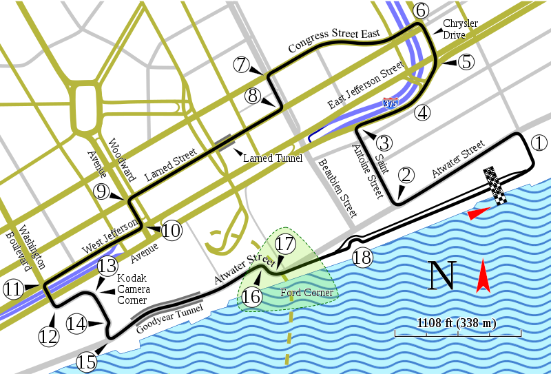
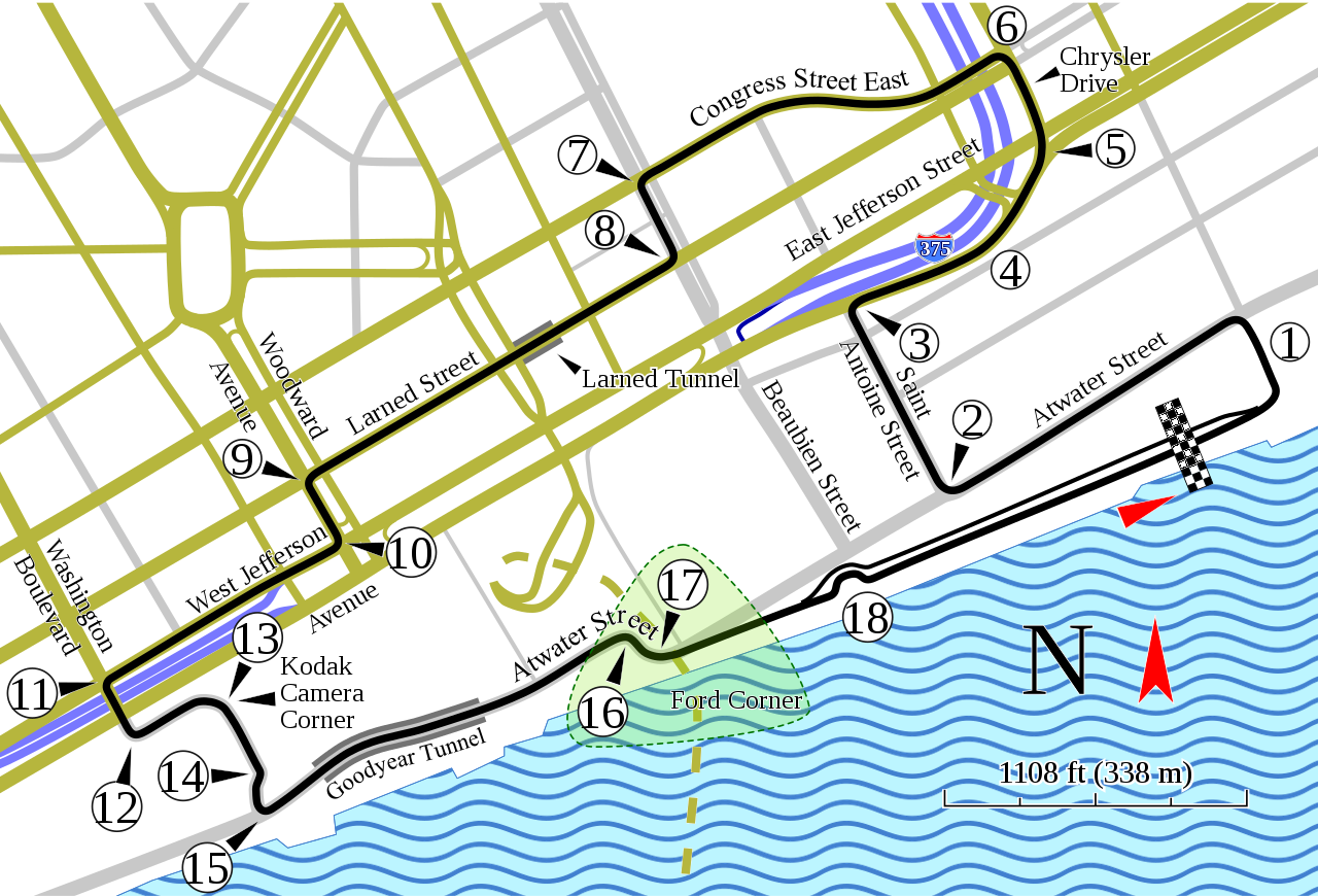
English: Track map of the former downtown Detroit street circuit. (Don't confuse this circuit with the one on Belle Isle.) |
| Datum | |
| Zdroj | Vlastní dílo; Source for course information: "1982 F1 US Grand Prix of Detroit report: Watson takes victory". Motor Sport (July 1982): 43. Retrieved on 28 October 2019. |
| Autor | Will Pittenger |
| Další verze |
|

| Pozice fotografa | | Tento snímek a mnohé další na: OpenStreetMap |
|---|
Licence
Tento soubor podléhá licenci Creative Commons Uveďte autora-Zachovejte licenci 3.0 Unported
- Dílo smíte:
- šířit – kopírovat, distribuovat a sdělovat veřejnosti
- upravovat – pozměňovat, doplňovat, využívat celé nebo částečně v jiných dílech
- Za těchto podmínek:
- uveďte autora – Máte povinnost uvést autorství, poskytnout odkaz na licenci a uvést, pokud jste provedli změny. Toho můžete docílit jakýmkoli rozumným způsobem, avšak ne způsobem naznačujícím, že by poskytovatel licence schvaloval nebo podporoval vás nebo vaše užití díla.
- zachovejte licenci – Pokud tento materiál jakkoliv upravíte, přepracujete nebo použijete ve svém díle, musíte své příspěvky šířit pod stejnou nebo slučitelnou licencí jako originál.
Historie souboru
Kliknutím na datum a čas se zobrazí tehdejší verze souboru.
| Datum a čas | Náhled | Rozměry | Uživatel | Komentář | |
|---|---|---|---|---|---|
| současná | 17. 1. 2016, 17:56 | | 1 553 × 1 055 (232 KB) | Soisyc Croisic | Fixed Atwater street name |
| 4. 10. 2008, 10:57 |  | 1 553 × 1 055 (236 KB) | Will Pittenger | Previous image had 3 text objects on paths. The current version of MediaWiki/RSVG hides such objects due to a bug. This version of the file gets around the bug by converting those objects into paths. If you need to edit the file, please use the old ver | |
| 4. 10. 2008, 10:53 |  | 1 553 × 1 055 (172 KB) | Will Pittenger | All new image with more reference points to help orient readers. NOTE: New image, new license! | |
| 2. 10. 2008, 23:14 |  | 1 534 × 994 (116 KB) | Will Pittenger | This version turns the text on path object that MediaWiki hides into a path. If you need to edit this file, please use the previous version. | |
| 2. 10. 2008, 23:13 |  | 1 534 × 994 (89 KB) | Will Pittenger | New version fixes misspelling in "Chrysler". Note: a text object is on a path in this version. An upcoming version will convert that text object into a path. If you need to edit this file, please use this version. | |
| 15. 7. 2008, 13:43 |  | 1 534 × 994 (114 KB) | Will Pittenger | New version gets around Mediawiki's bug in handling text on paths by converting that text to path objects. If you need to edit the file, please use the previous version. | |
| 15. 7. 2008, 13:38 |  | 1 534 × 994 (61 KB) | Will Pittenger | {{Information |Description={{en|1=Track map of the former downtown w:Detroit street circuit. (Don't confuse this circuit with the one on w:Belle Isle.)}} |Source=Own work by uploader |Author=Will Pittenger |Date=7-15-200 |
Využití souboru
Tento soubor používají následující 2 stránky:
Globální využití souboru
Tento soubor využívají následující wiki:
- Využití na af.wikipedia.org
- Využití na ast.wikipedia.org
- Využití na bg.wikipedia.org
- Využití na bn.wikipedia.org
- Využití na da.wikipedia.org
- Využití na de.wikipedia.org
- Využití na en.wikipedia.org
- List of Formula One circuits
- 1982 Formula One World Championship
- 1983 Detroit Grand Prix
- 1984 Detroit Grand Prix
- Detroit street circuit
- Detroit Grand Prix (IndyCar)
- List of Champ Car circuits
- User talk:Chubbennaitor/archive2
- User talk:Barkjon/Archive 2
- Wikipedia:WikiProject Formula One/Newsletter/200808
- User talk:Hellboy2hell/archive2
- User talk:NapHit/Archive 1
- User talk:4u1e/archive5
- User talk:Typ932/Archive 3
- User talk:Midgrid/Archive 6
- User talk:Thelb4/Archive 5
- User talk:Chubbennaitor/Archive7
- Detroit Grand Prix
- User talk:Readro/Archive 3
- User talk:Donnie Park/Archive 1
- User talk:The359/Archive 4
- User talk:Cs-wolves/Archive 3
- User talk:Bam123456789/Archive 1
- 1985 Detroit Grand Prix
- 1986 Detroit Grand Prix
- 1987 Detroit Grand Prix
- User talk:Sage Callahan/Archive 1
- User talk:Cdhaptomos/Archive 1
- User:TorontoGuy79/sandbox
- User talk:Spenalzo/Archive/2008
- User talk:Clyde1998/Archive/2008
- Využití na es.wikipedia.org
- Využití na et.wikipedia.org
- Využití na eu.wikipedia.org
- Využití na fa.wikipedia.org
- Využití na fr.wikipedia.org
Zobrazit další globální využití tohoto souboru.