Soubor:Cape Cod ISS.JPG

Obsah stránky není podporován v jiných jazycích.
Z Wikipedie, otevřené encyklopedie

Původní soubor(3 032 × 2 008 pixelů, velikost souboru: 2,9 MB, MIME typ: image/jpeg)

Popis

Popis
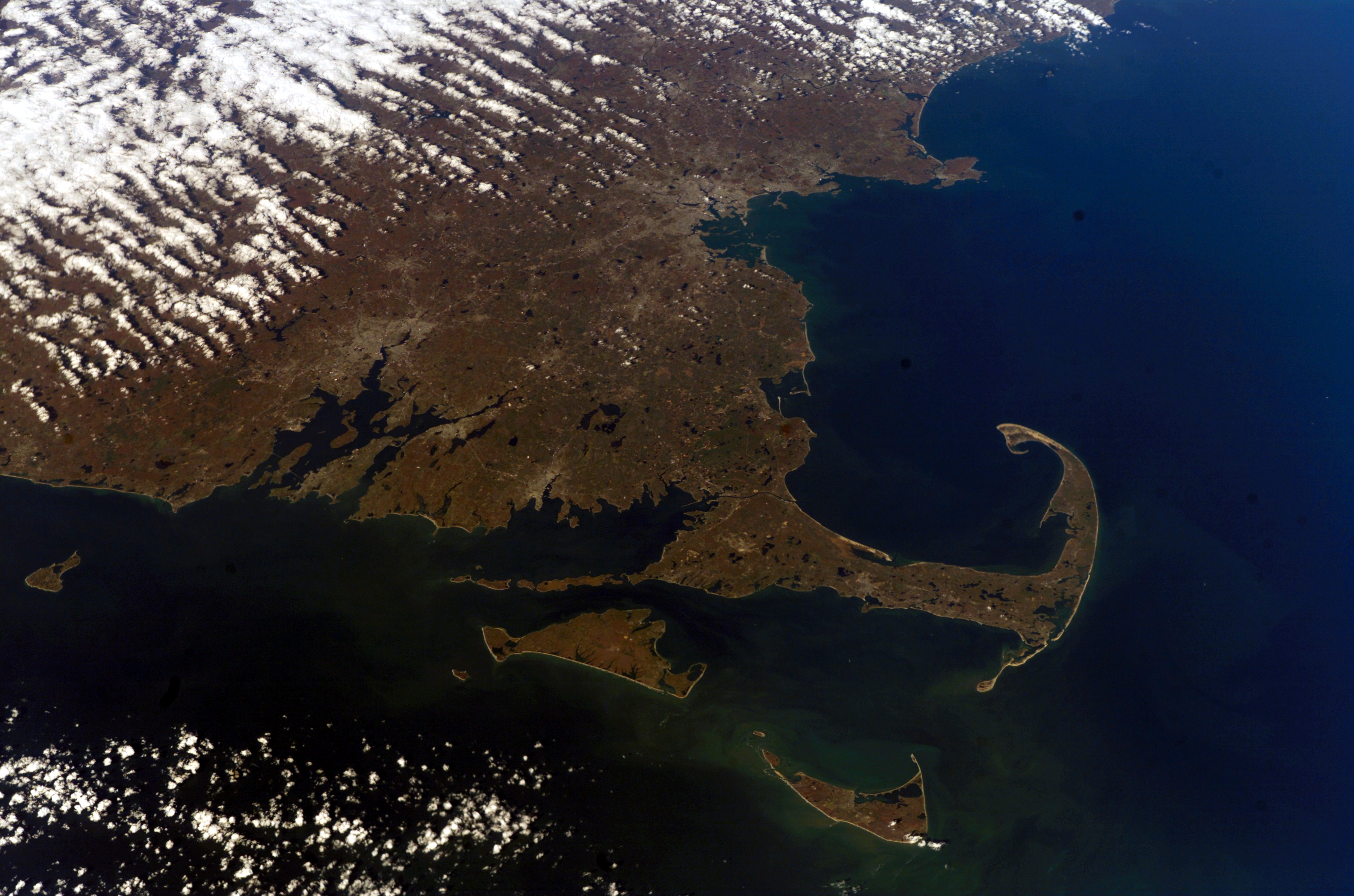
English: The arm-shaped peninsula of Massachusetts is shown here in a digital photograph from astronauts aboard the International Space Station.


International Space Station InsigniaISS Crew Earth Observations: ISS016-E-10312International Space Station Insignia
Identification
Mission ISS016 (Expedition 16)
Roll E
Frame 10312
Country or Geographic Name USA-MASSACHUSETTS
Features CAPE COD
Center Point Latitude 42.0° N
Center Point Longitude -71.0° E
Camera
Camera Tilt 48°
Camera Focal Length 70 mm
Camera E4: Kodak DCS760C Electronic Still Camera
Film 3060E : 3060 x 2036 pixel CCD, RGBG array.
Quality
Percentage of Cloud Cover 11-25%
Nadir What is Nadir?
Date 2007-11-07
Time 16:29:38
Nadir Point Latitude 39.0° N
Nadir Point Longitude -69.5° E
Nadir to Photo Center Direction North
Sun Azimuth 182°
Spacecraft Altitude 181 nautical miles (335 km)
Sun Elevation Angle 35°
Original image caption
Settling on the Coast

Cape Cod is a haven for waves of migrants who have washed up on American shores. The most famous arrived in the early 1600s, and hundreds of thousands now visit every summer. But most of the migrants washed up between 18,000 and 23,000 years ago.

In September 1620, English Separatists, also called the Pilgrims, left Europe to set up a colony near the mouth of the Hudson River. On November 20, they sighted land and confirmed it to be Cape Cod. This arm-shaped peninsula of Massachusetts is shown here in 2007 in a digital photograph from astronauts aboard the International Space Station.

The Pilgrims initially decided to sail farther south, but quickly became wary of the shallow waters and shoals east and south of Cape Cod and Nantucket—waters full of the sandy, rocky outwash from ancient glaciers. They sailed around the northeastern tip of the Cape and on November 21, 1620, dropped anchor just off the shores of modern-day Provincetown. While resting in that harbor, they composed and signed the Mayflower Compact, an agreement to establish self-government.

In the weeks that followed, the Pilgrims explored the Cape and made their first encounter with the Wampanoag Indians, native people whose ancestors may have explored and inhabited Cape Cod as early as 11,000 years ago. Eventually, the Pilgrims made their way to the western shores of Cape Cod Bay, landing near an abandoned Wampanoag settlement known as Patuxet.

Plymouth Rock—which is likely a creation of oral history and legend, since there is no mention of it in the writings of the original Mayflower voyagers—is a glacial erratic, a large boulder that dropped out of a glacier.

The Cape’s sandy peninsula and a fair bit of southeastern Massachusetts is, in a way, also a migrant. The area was both built up and scoured by the Laurentide Ice Sheet, which stretched down past Martha’s Vineyard and Nantucket during Earth’s last major Ice Age. In their advance and retreat, the glaciers composing the ice sheet scraped rock off of Earth’s surface, eventually depositing it on Cape Cod. The U.S. Geological Survey estimates that the deposits are 200 to 600 feet thick across the region.

Though this photo cannot show all the rocks left behind, it does show the dozens of kettle hole ponds. As the ice sheet retreated, sediments washing out of the glaciers occasionally covered chunks of ice. Those ice blocks would eventually melt and collapse the sediments, creating the space for the fresh groundwater-fed ponds we see today.

Editor’s Note: On the original Mayflower Compact, the date is listed as November 11. When Western societies switched from the Julian calendar to the Gregorian calendar, 10 days were added, turning November 11 into November 21.

Datum
Zdroj Gateway to Astronaut Photography of Earth
Autor ISS Expedition 16 crew
Pozice fotografa39° 00′ 00″ s. š., 69° 30′ 00″ z. d.  Heading=0° Kartographer map based on OpenStreetMap.Tento snímek a mnohé další na: OpenStreetMapinfo
Pozice objektu42° 00′ 00″ s. š., 71° 00′ 00″ z. d. Kartographer map based on OpenStreetMap.Tento snímek a mnohé další na: OpenStreetMapinfo
Tento mediální soubor byl katalogizován v Johnsonově vesmírném středisku amerického Národního úřadu pro letectví a kosmonautiku (NASA)pod Photo ID: ISS016-E-10312.

Toto oznámení nepopisuje autorskoprávní status tohoto souboru. Stále je vyžadován běžný popisek licence. Další informace najdete na Commons:Licencování.
Jiné jazyky:

Licence

Public domain This file is in the public domain in the United States because it was solely created by NASA. NASA copyright policy states that "NASA material is not protected by copyright unless noted". (See Template:PD-USGov, NASA copyright policy page or JPL Image Use Policy.)
Warnings:
Poznámky
InfoField
K tomuto souboru existují poznámky: Prohlédnout si poznámky na Commons

Popisky

Přidejte jednořádkové vysvětlení, co tento soubor představuje

Položky vyobrazené v tomto souboru

zobrazuje

39°0'N, 69°30'W

směr pohledu: 0 stupeň

3d353bd362e4a532d79992963338c48e69aaefa6

3 039 853 bajt

2 008 pixel

3 032 pixel

Historie souboru

Kliknutím na datum a čas se zobrazí tehdejší verze souboru.

Datum a časNáhledRozměryUživatelKomentář
současná22. 11. 2010, 15:29Náhled verze z 22. 11. 2010, 15:293 032 × 2 008 (2,9 MB)Originalwana{{Information |Description={{en|1=This arm-shaped peninsula of Massachusetts is shown here in a digital photograph from astronauts aboard the International Space Station.}} |Source=[http://earthobservatory.nasa.gov/IOTD/view.php?id=47138 NASA Earth Ob

Tento soubor používá následující stránka:

Globální využití souboru

Tento soubor využívají následující wiki:

Metadata