
Soubor:British Empire Anachronous 7.png
Velikost tohoto náhledu: 800 × 370 pixelů. Jiná rozlišení: 320 × 148 pixelů | 640 × 296 pixelů | 1 357 × 628 pixelů.
Původní soubor (1 357 × 628 pixelů, velikost souboru: 48 KB, MIME typ: image/png)
| Tento soubor pochází z Wikimedia Commons. Níže jsou zobrazeny informace, které obsahuje jeho tamější stránka s popisem souboru. |
Popis

|
Tento obrázek (skupina historical map) by měl být vytvořen pomocí vektorové grafiky jako SVG soubor. To má několik výhod; podrobnosti najdete na stránce Commons:Media for cleanup. Je-li SVG verze tohoto obrázku již k dispozici, prosím nahrajte ji. Po nahrání nahraďte tuto šablonu šablonou {{Vector version available|jméno nového obrázku.svg}}.
|

|
Tento soubor byl nahrazen souborem File:The British Empire.png. Je doporučeno používat nový soubor.
|
| Popis |
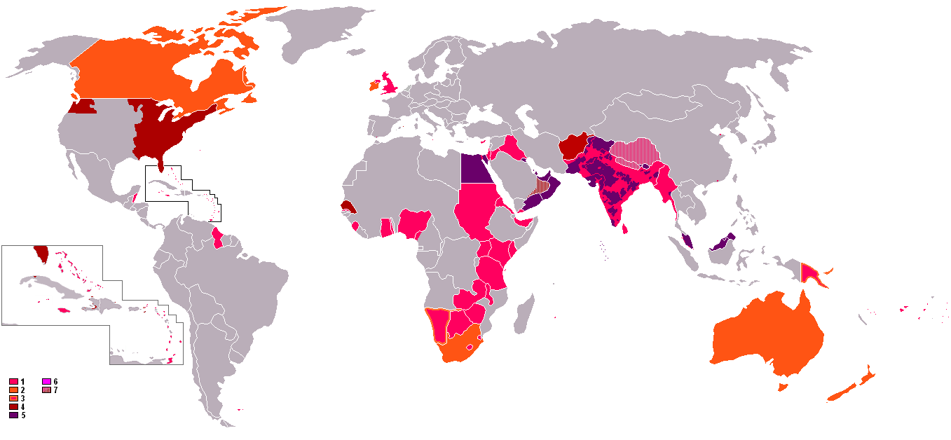
English: : An anachronous map of the British Empire (showing its many forms of control). The colours in the map key are explained according to their related numbers as follows:
|
| Datum | 8. října 2006 (datum prvotního načtení souboru) |
| Zdroj | Na Commons přeneseno z en.wikipedia. |
| Autor | Původně soubor načetl Gsd2000 na projektu Wikipedie v jazyce angličtina |
Licence

|
Tento dokument smí být kopírován, šířen nebo upravován podle podmínek Svobodné licence GNU pro dokumenty verze 1.2 nebo libovolné vyšší verze publikované nadací Free Software Foundation. Dokument nemá neměnné části ani texty na předním či zadním přebalu. Kopie textu licence je k dispozici v oddíle nazvaném GNU Free Documentation License. |
| Tento soubor podléhá licenci Creative Commons Uveďte autora-Zachovejte licenci 3.0 Unported | ||
| ||
| Tato licenční šablona byla k tomuto souboru přidána v rámci změny licencování. |
Původní historie souboru
Původní stránka s popisem souboru byla zde. Všechna následující uživatelská jména odkazují na projekt en.wikipedia.
- 2006-10-08 13:08 Gsd2000 1357×628×8 (42019 bytes)
Historie souboru
Kliknutím na datum a čas se zobrazí tehdejší verze souboru.
| Datum a čas | Náhled | Rozměry | Uživatel | Komentář | |
|---|---|---|---|---|---|
| současná | 8. 11. 2021, 01:41 | | 1 357 × 628 (48 KB) | Randomastwritter | jubaland |
| 31. 10. 2021, 10:04 |  | 1 357 × 628 (48 KB) | Randomastwritter | . | |
| 13. 6. 2009, 21:47 |  | 1 357 × 628 (41 KB) | Mnmazur | Reverted to version as of 20:37, 20 September 2007 - Spheres of influnce extended beyond Tibet but did not cover the entire country. Firthermore, even if they had, that map uses current Chinese borders and therefore filling in the country just doesn't wo | |
| 18. 4. 2008, 15:01 |  | 1 357 × 628 (55 KB) | LaGrandefr~commonswiki | {{Information |Description= {{en}}: An anachronous map of the British Empire (showing its many forms of control). The colours in the map key are explained according to their related numbers as follows: *1.Pink: colonies held by 1945 *2.Orange:Dominions | |
| 20. 9. 2007, 22:37 |  | 1 357 × 628 (41 KB) | Tarret | {{Information |Description=An anachronous map of the British Empire (showing its many forms of control). The colours in the map key are explained according to their related numbers as follows: *1.Pink: colonies held by 1945 *2.Orange:Dominions *3.Pink in |
Využití souboru
Tento soubor používá následující stránka:
Globální využití souboru
Tento soubor využívají následující wiki:
- Využití na ro.wikipedia.org
- Využití na th.wikipedia.org