
Soubor:Europäische Wasserscheiden.png

Původní soubor (1 200 × 1 184 pixelů, velikost souboru: 526 KB, MIME typ: image/png)
| Tento soubor pochází z Wikimedia Commons. Níže jsou zobrazeny informace, které obsahuje jeho tamější stránka s popisem souboru. |
Popis
| Popis |
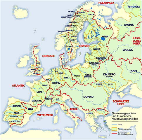
Deutsch: Grafik zeigt die Europäischen Flusseinzugsgebiete und Hauptwasserscheiden.
Zeichnung erstellt 06/2004 von Sansculotte. Bild ist unter der Creative Commons Share Alike zur weiteren Verwendung freigegeben. Quellenangabe und Beleg an sansculotte@despammed.com erbeten.English: The map shows the European rivers' catchment areas and main watersheds.
Chart made on 06/2004 by de:Sansculotte. The image is released under the Creative Commons Share Alike license for futher use. Reference and sources can be requested from sansculotte@despammed.comFrançais : Carte des bassins fluviaux d'Europe. Carte établie en juin 2004 par le contributeur de:Sansculotte
Sources (!) disponibles par demande à sansculotte@despammed.com
|
||||||||
| Datum | |||||||||
| Zdroj | Source: German Wikipedia, original upload see file history | ||||||||
| Autor | Sansculotte | ||||||||
| Svolení (Užití tohoto souboru) |
Tento soubor podléhá licenci Creative Commons Uveďte autora-Zachovejte licenci 2.0 Generic
|
||||||||
| Další verze |
Díla odvozená od tohoto souboru:
|


|
File history German Wikipedia
(Löschen) (Aktuell) 16:54, 15. Jan 2005 . . Sansculotte . . 1200x1184 (602233 Byte) (korr.)
(Löschen) (Zurücksetzen) 05:01, 3. Jun 2004 . . Sansculotte . . 1000x987 (262710 Byte) (eigene Darstellung, GNU FDL, Europäische Flußeinzugsgebiete und Hauptwasserscheiden)
(Löschen) (Zurücksetzen) 04:21, 3. Jun 2004 . . Sansculotte . . 1000x987 (183238 Byte) (eigene Darstellung, GNU FDL, Europäische Flußeinzugsgebiete und Hauptwasserscheiden)
Historie souboru
Kliknutím na datum a čas se zobrazí tehdejší verze souboru.
| Datum a čas | Náhled | Rozměry | Uživatel | Komentář | |
|---|---|---|---|---|---|
| současná | 31. 7. 2019, 10:45 | | 1 200 × 1 184 (526 KB) | 1970gemini | entschleiert |
| 16. 5. 2016, 03:21 |  | 1 200 × 1 184 (279 KB) | Ulamm | - Klare Farben für klar eInformationen - Ladogasee und finnische Flüsse nachgetragen - Wasser aus den Kattegat-Zuflüssen fließt nicht in die Ostsee; Zuordnung des Kattegat zur Ostsee nautisch und mangels eigener Meereseinheit | |
| 17. 1. 2016, 00:03 |  | 1 200 × 1 184 (766 KB) | Francis McLloyd | Grenzen in Südschweden, im Osten von Dänemark und westliche Ostsee ergänzt (jetzt) | |
| 16. 1. 2016, 23:59 |  | 1 200 × 1 184 (763 KB) | Francis McLloyd | Grenzen in Südschweden, im Osten von Dänemark und westliche Ostsee ergänzt | |
| 16. 1. 2016, 22:21 |  | 1 200 × 1 184 (760 KB) | Francis McLloyd | Grenze im Nord-Osten zwischen Newa und Kemijoki verbessert. Gebiete westlich des Newas hinzugefügt. | |
| 11. 3. 2011, 21:12 |  | 1 200 × 1 184 (723 KB) | W like wiki | a small part of the Adria-Mittelmeer drainage was missing. But i don t have time to check exactly, thats why only doted line. | |
| 11. 3. 2011, 20:14 |  | 1 200 × 1 184 (724 KB) | W like wiki | Drainage divide in Italy, Denmark, UK and Gibraltar corrected. By the way: If someone have time and a better map than me, the doted line in Finnland should be replaced by "full line". | |
| 7. 1. 2011, 15:59 |  | 1 200 × 1 184 (849 KB) | Care | Saimaa fix | |
| 24. 2. 2010, 16:44 |  | 1 200 × 1 184 (564 KB) | Dcoetzee | Remove watermark, pngcrush | |
| 2. 7. 2009, 21:26 |  | 1 200 × 1 184 (552 KB) | NordNordWest | Danube corrected, plus names of Vardar and Mariza |
Využití souboru
Tento soubor používá následujících 6 stránek:
Globální využití souboru
Tento soubor využívají následující wiki:
- Využití na af.wikipedia.org
- Využití na als.wikipedia.org
- Využití na ar.wikipedia.org
- Využití na arz.wikipedia.org
- Využití na az.wikipedia.org
- Využití na ba.wikipedia.org
- Využití na be-tarask.wikipedia.org
- Využití na be.wikipedia.org
- Využití na bg.wikipedia.org
- Využití na bs.wikipedia.org
- Využití na ceb.wikipedia.org
- Využití na da.wikipedia.org
- Využití na de.wikipedia.org
- Donau
- Niedersachsen
- Ostsee
- Rhein
- Elbe-Lübeck-Kanal
- Wasserscheide
- Liste von Flüssen in Europa
- Dietweis
- Wikipedia:Kandidaten für exzellente Bilder/Archiv2005/1
- Wasserscheiden in den Alpen
- Benutzer:Alopex/Tipps
- Portal Diskussion:Geographie/Bild des Monats
- Einzugsgebiet
- Geographie Europas
- Wikipedia:Exzellente Bilder/Karten und Satellitenbilder
- Diskussion:Schartenhöhe
- Europäische Hauptwasserscheide
- Benutzer:NatiSythen/Karten
- Benutzer:WA1TF0R/Galerie
- Benutzer:Mikullovci11/Work/Karten
- Benutzer:Wesn/todo
- Benutzer Diskussion:Watzmann/Archiv/2013
- Lichtenstein (Gemeinde Schenkenfelden)
- Datei:Europäische Wasserscheiden.png
- Benutzer:Francis McLloyd/Oder/Becken
- Benutzer:Francis McLloyd/Ostsee/Becken
- Benutzer:Francis McLloyd/Pregel/Becken
- Benutzer:Francis McLloyd/Windau/Becken
- Benutzer:Francis McLloyd/Bucht/bei Riga
- Benutzer:Francis McLloyd/Lielupe/Becken
Zobrazit další globální využití tohoto souboru.